About 12% of the Earth's land is used for growing crops. As the world’s population grows, greater demands are placed on agriculture than ever before, and growers are depending on satellite data to increase their crops.
 Readers Choice 2020: Satellite Imaging for Agriculture
Article from | Len Calderone
The global need for food is projected to double by 2050 because of population growth, dietary change, and bioenergy use, while droughts alone reduced global crop production by 10%, and farming land is being degraded by soil erosion, and mineral exhaustion.
About 12% of the Earth's land is used for growing crops. As the world’s population grows, greater demands are placed on agriculture than ever before, and growers are depending on satellite data to increase their crops.
Geospatial technologies are used to map three-dimensional disparities in crop and soil conditions so that growers will know what to add, such as water, seed, and fertilizer. Zone maps show the discrepancy between healthy and stressed plants by denoting the amount of light that they are reflecting in different bands of the electromagnetic range; while prescription maps tell the growers how much water, seed, and fertilizer to apply to each of smaller areas known as management zones.
The number of surveillance satellites are expanding the quantity and quality of the data that is available to growers and consultants. Satellite views help them quickly detect seasonal problems regarding nutrient deficiencies, pests, and disease. This information gives them the best chance to correct issues that would constrain crop performance.
Satellites are used to portray a grower’s fields in detail. When used in combination with geographical information systems (GIS), satellites help with more concentrated and efficient crop growing practices. As an example, different crops might be suggested for different fields while the use of fertilizer can be adjusted in a cost-effective and environmentally friendly manner.
A geographic information system (GIS) is a computer system that is used to capture, store, check, and display data related to positions on the Earth’s surface. By connecting seemingly unrelated data, GIS can help growers to better understand spatial patterns and relationships.
GIS is not new in agriculture. Natural inputs in farming cannot be controlled, but they can be better recognized and managed with GIS applications. GIS can significantly help with valuable crop yield estimates, soil amendment analyses and erosion remediation. Accurate and dependable crop estimates help lessen uncertainty.
Reconnaissance satellites orbit the Earth at a relatively low altitude and take sharp images of the Earth. The majority of today's satellites are custom made and adapted to the particular needs of the user. A reconnaissance satellite is equipped with high resolution CCD (Charge-Coupled Device) cameras. These are coupled large lenses that are able to take high resolution pictures of the ground below them. Image quality is this satellite’s key feature. Generally, the bigger the lens, the better the picture quality with greater detail.
DigitalGlobe’s GeoEye-1 satellite was launched on September 6, 2008. The GeoEye-1 satellite has a high-resolution imaging system with ground resolution images of 16 inches in the panchromatic mode. And 64 inches in the multispectral or color imagery mode.
.png)
DigitalGlobe’s GeoEye-1 satellite
Up until now, satellite imagery was simply not frequent enough to react to crop stress in a timely manner. Now, daily imagery is a game changer for agriculture. Growers can recognize changes in vegetation from preseason to harvest, which helps them farm more efficiently, and profitably with constant field coverage.
Frequent imagery allows for crop health monitoring because of continuous field coverage over wide and distributed areas. Easy access imagery along with historical archiving of images can improve productivity within dynamic management zones.
Sub-Saharan Africa has 50% of the world’s agricultural land, but only about 1% of that land is suitable for long-term cultivation, due to nutrient deficiencies in the soil and poor land management,along with pests and agricultural diseases. The Africa Soil Information Service (AfSIS) team is mapping the soil texture, moisture levels, and nutrient levels, across the continent. The African soil maps are the first of their kind. They combine data from satellite images and existing soil samples. The maps serve to show local growers where they can maximize their food production.
.png)
Photo: en.wikipedia.org
In Australia, satellite data is used to aid farmers in understanding harvest readiness. The sugar cane industry uses in-season and historical satellite data alongside weather and planting data to estimate at a field level across the growing season to indicate which fields were ready for harvest and in which months. This planning was required to schedule trains to transport the harvested sugar cane to the mills for processing.
Advancements in artificial intelligence (AI) have made autonomous, large scale analysis of photographic imagery possible. AI has demonstrated that it can manage satellite imagery with very little error; and AI can differentiate between different forest types, as well as certain soil and vegetation varieties. Researchers use AI to monitor satellite imagery for vineyard and grape health as well as estimate wheat harvest size.
GOES-8 is a United States weather satellite that is chiefly used to observe the weather and climate of the Earth. For growers, weather is very serious business, as just the right amount of water and the right temperature is needed for their crops to grow well. A team of satellites, called the Joint Polar Satellite System (JPSS) is assisting to monitor and forecast severe weather conditions. The more information that growers have about weather conditions, the better they can react to potential disasters.
Information from visible and infrared light can be used to determine the health of plants in a certain region. For example, a weather satellite can determine how much stress plants are under in a region of extreme drought, such as California’s central valley, which is an important farming region, during its severe drought season.
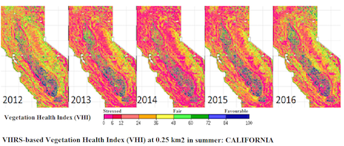
Credit: NOAA
Blue areas show healthy vegetation. Pink areas are where the plants are in extreme stress. Looking closely at these images, we can tell that a rain late in the spring of 2015 provided some relief to the stressed crops.
Satellites and digital technologies utilized by the agri-tech industry has the potential to transform current farm management practices. Access to information about the real-time status of soil, water, and crops will enhance operational planning and decision making, while facilitating substantial productivity gains across the farming industry. This will lead to the adoption of meticulous farming technologies that are vital to the world’s agricultural industry.
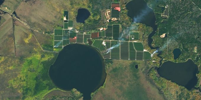
*Title Courtesy: Landsat, NASA
The content & opinions in this article are the author’s and do not necessarily represent the views of AgriTechTomorrow
Comments (0)
This post does not have any comments. Be the first to leave a comment below.
Featured Product