Persistence Unlocks True Precision Agriculture
Precision agriculture has spent the last decade relying on a “snapshot” approach to aerial data collection. Farmers and agronomists deploy battery-powered drones for 15 to 20-minute flights to capture critical data best seen from an elevated vantage point. While valuable, this approach creates wide gaps in the data timeline.
Biological systems are dynamic. A crop’s water-stress levels can fluctuate dramatically throughout the day, often peaking in the early afternoon when battery-powered drones are grounded due to high heat or thermal turbulence. Many pests are also nocturnal or crepuscular, moving across fields at times when standard drones are sitting in their cases.
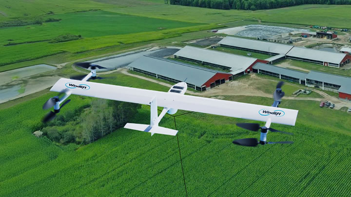
To move from periodic scouting to persistent intelligence, the industry is pivoting toward a new class of aerial infrastructure: Active Tethered UAVs. Unlike passive aerostats, which are bulky and fragile, these are dynamic, high-performance aircraft that maintain a physical link to the ground to achieve what batteries cannot: infinite endurance and meaningful wind resilience.
Technology Shift: Ground-Powered Tethered Multirotors
Active tethered multirotors utilize a micro-tether to draw continuous power from a ground station connected to the grid or a generator. With uninterrupted energy and a stable physical link to the ground, these systems can maintain station at altitudes up to 400 feet indefinitely.
They rely on adaptive flight algorithms that sense tension on the tether and adjust motor torque milliseconds faster than a human pilot could. This allows them to remain rock-steady in winds up to 25 mph, conditions that would send a standard drone drifting off-course or crashing into the canopy. Emerging advancements have been working on a solution that expands that operating window to winds over 55 mph.
While remote farms can have limited cellular bandwidth, tethered systems can utilize a fiber-optic core inside the cable. This enables the transmission of uncompressed, 4K video or heavy LiDAR point clouds in real-time without fear of signal jamming or loss. Because the tether provides both power and bandwidth, much of the computational workload can be shifted to the ground station, avoiding the weight constraints of onboard processing. The drone effectively becomes a flying server that processes "Edge AI" data and sends only actionable alerts. Tethered systems unlock aerial sensor persistence in an unprecedented way.
The Agronomic Value of Persistence
The reason persistence matters is that specific agronomic data points only reveal themselves over time rather than in a 15–20-minute snapshot.
Plants regulate temperature through transpiration. When water is scarce, stomata close and canopy temperature spikes. This Crop Water Stress Index (CWSI) is most accurate during "solar noon" between 1:00 PM and 3:00 PM, usually the windiest and hottest part of the day.
A tethered drone equipped with a thermal sensor can loiter over a center-pivot irrigation circle for the entire diurnal cycle. It captures the gradual rise in canopy temperature and identifies stress before visual wilting occurs. A snapshot flight at 10:00 AM would miss this entirely, leading to a false diagnosis of "healthy."
Many aggressive pests, such as certain moth species or beetles, are photophobic. They avoid light and hide under leaves during the day.
A tethered system can hover continuously through dusk and into the night. Using high-resolution thermal or near-infrared optics, it can detect the thermal signature of pest clusters or the physical movement of swarms as they emerge. This allows for "precision strikes" with pesticides only in the affected zones rather than blanketing the whole field based on a guess.
These systems can also be deployed for security purposes. With advancements in EO/IR cameras, one tethered system could easily monitor 2000 or more acres.
The Path Forward
The adoption of active tethered systems represents maturity in AgTech. We are moving past the novel phase of simply flying a drone and into the phase of building actual infrastructure, installing a persistent aerial sensor array. With these elevated platforms deploying an array of aerial sensors collecting data constantly rather than in shorter bursts, the future of autonomous precision agriculture has truly taken flight.

Sean Meyer is Chief Operating Officer at Windlift, a North Carolina–based company developing autonomous, resilient, tethered UAV systems for defense, energy, and agricultural applications. Prior to Windlift, Sean spent 15+ years in senior leadership with vineyards in California. For more information, visit windlift.com.
Comments (0)
This post does not have any comments. Be the first to leave a comment below.
Featured Product