Using an in-expensive drone, they can map a full quarter section of land in about 20 minutes, providing a real-time map that is able to instantly show variability and allow them to quickly identify problem areas and determine solutions.
 2022 Top Article - Drones and Robotics in Agriculture
Q&A with Mike Winn, CEO and Co-Founder | DroneDeploy
How are drones and robotics being used in agriculture? And how is this different from other farming robotics tools?
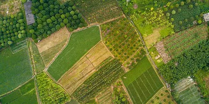
Drones are an incredible crop scouting tool, enabling users to get a bird’s eye view of their fields in minutes. There are a variety of use cases. Growers and advisors use drones to discover variability in their fields. Agricultural insurers use drones after weather events, helping them evaluate crop damage claims with accurate crop damage maps. And agronomists collect high accuracy plant-vigor maps to create nitrogen and pesticide prescriptions.
Instead of searching the whole field for issues, drone users have an autonomous scout to get the lay of the land for them. Using an in-expensive drone, they can map a full quarter section of land in about 20 minutes, providing a real-time map that is able to instantly show variability and allow them to quickly identify problem areas and determine solutions.
In row crops, companies like Corteva, Syngenta and Bayer have hundreds of drones, enabling their teams to provide better advice to their customers. In specialty crops, companies like Bowles Farming are using DroneDeploy’s plant health tools to identify areas that need pesticide, assess drip irrigation leaks and help determine the exact time their cotton crop is ripe for harvest. By using highly accurate aerial insights, the farm can make better decisions, increase productivity and ultimately lower costs.
Drones are the most ubiquitous type of robot on farms today covering millions of acres of fields every year. Other types of robots are emerging, including autonomous tractors and specialist picking-robots - but so far the costs are high, and reliability is still being proven. When equipped with the right software, drones are the most reliable, affordable, and efficient robot investments for the industry.
What insights can DroneDeploy secure for farmers from its drone and mapping technology? How do ground robotics fall into this?
DroneDeploy provides its customers with information that can support production teams, retailers, field managers, research and development, and more. Some of our key features include:
- Stand Count: Developed with Corteva Agriscience, Stand Count removes the need for manual, time-consuming, inaccurate stand counts. It provides a fully automated, offline workflow to evaluate crop emergence in minutes, able to do population counts for a 100-acre field in less than 30 minutes, all at the field’s edge.
- Live Mapping Technology: DroneDeploy’s technology is fully capable of being offline and mobile, allowing the user to take the technology wherever it is needed. Users can create and view field-maps in real-time, allowing them to scout crops more effectively and make better decisions.
- Crop Health Maps: These evaluate field variability with sophisticated agronomic indices, able to highlight damaged crops, areas infected with pests or patches with nitrogen deficiency. From these flight maps, users can break down the information for health analysis and quickly understand the acreage needing attention.
At DroneDeploy, we’re expanding beyond aerial drones. Now, DroneDeploy doesn’t just automate and process imagery from drone flights - it can also program ground robotic routes and capture data from the ground. For example, a drone can scan a field from above to identify problem spots, then automatically dispatch a ground rover to capture a more up-close, detailed overview of the issue - or even be sent to fix the issue (e.g. spray the area with pesticide). Eventually, aerial and ground robotics will work in tandem to capture data, analyze it using AI, and then act on it.
How does being a cloud and mobile-based platform benefit the agriculture industry?
Increasingly, we’ve seen agriculture companies expect to run their businesses from their smartphones. They’re getting information they need from the cloud - like the weather, soil data and commodity prices - all at once, and are able to connect to machinery from pivot irrigators to see equipment activity.
Smartphones can also operate drones. With just a tap, users can access high resolution screens that show live field data - right from their pocket at any time they need. Cloud capability is critical to expanding the computer and storage capability of smartphones, as well as enable users to share data instantly to any advisor anywhere in the world.
While mobile and cloud are critical for today's workflow, it’s important that products also work without requiring internet access, given the realities of working in (often) far-flung fields. That’s why both DroneDeploy’s products LiveMap and Stand Count work totally offline at the field edge on iOS.

About Mike Winn
Mike Winn is the co-founder and CEO of DroneDeploy, the leading enterprise-grade site reality platform. The software converts job sites, structures, and assets into easy-to-understand digital representations, generating valuable insights for industries including construction, energy, and agriculture. Through mapping, 3D modeling, analysis, and reporting, it provides a detailed and accurate digital replica of any asset, enabling customers to take action, save time, and lower unforeseen costs. Beginning as a conservation-based project, the company now has global offices in the US and Australia and has raised $142M to-date.
The content & opinions in this article are the author’s and do not necessarily represent the views of AgriTechTomorrow
Comments (0)
This post does not have any comments. Be the first to leave a comment below.
Featured Product