The Normalized Difference Vegetation Index (or NDVI) has been used for the past 40 years as the go-to method of assessing plant health. As you may know, healthy plants reflect light differently than unhealthy ones.
NDVI Vs. False-NDVI - What's Better for Analyzing Crop Health?
Kyler Olson | Botlink
It’s time to tackle a subject within agriculture that can be a little confusing, even to many people within the industry. So sit back, get comfortable, and let's dive in! The subject we’re talking about? Crop health and how to measure it. More specifically, we’ll look over the various methods of measuring crop health and how to ensure accurate results to improve yields. But first, let’s start with a little background on the main method of measuring crop health - the NDVI algorithm.
The Normalized Difference Vegetation Index (or NDVI) has been used for the past 40 years as the go-to method of assessing plant health. As you may know, healthy plants reflect light differently than unhealthy ones. Scientists decided to take advantage of this intriguing finding by creating the NDVI algorithm.
In precision agriculture, using the NDVI algorithm provides growers with an accurate measurement of crop health and enables them to zero in on problem areas that may need further attention. This has been the standard for understanding plant health in the agriculture industry for many years. And now, with emerging drone technology, it’s becoming even easier to utilize this valuable algorithm.
NDVI has traditionally been captured by satellites or airplanes. Using these methods meant growers would often have to wait days or longer to get their imagery back. They were also an expensive way to gain information. Today, drones are completely changing the game. Growers can purchase drones and non-infrared (NIR) capable cameras to collect NDVI imagery on demand, making it both more affordable and accessible than methods used in the past.
Now that you know some background on NDVI, let’s take a closer look into how drones can be used to accurately measure crop health whenever you want. At the beginning of the descent into this subject, you should be familiar with the two types of sensors for drones:

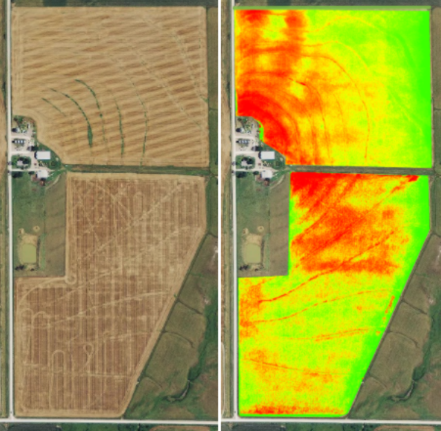
(left image) Shows a field captured with a normal RGB camera. (right image) Shows the same field with the NDVI algorithm applied to it, captured with an NIR camera.
RGB vs. NIR Sensors
RGB Sensors: The first and most common sensor is the RGB (red, green, and blue) sensor. This sensor uses bands of light that the human eye is sensitive to and can visibly see. RGB sensors recreate images that are almost exactly like what we see with our eyes and come equipped on most standard drones that have cameras out of the box. Basically, the RGB camera on a drone is just like the camera on your phone! It's OK to use RGB sensors for your field if you are starting out with a drone since they are fairly cheap. Additionally, most consumer drones like the DJI™ Phantom come equipped with them. These sensors are great for creating orthomosaic maps that show your entire field at once, among other uses. Although RGB sensors have many valuable uses, we prefer another method for measuring crop health. This is because with RGB, you need to use False-NDVI for crop measurement. We’ll get into what exactly false-NDVI is momentarily. Before that, let’s talk about the second sensor for drones.

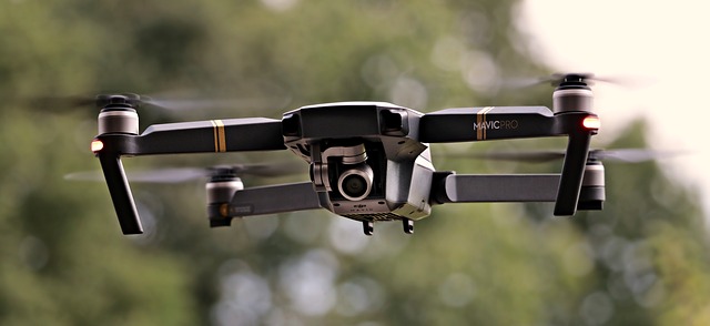
Pictured is the DJI™ Mavic consumer drone that comes equipped with a standard RGB sensor.
NIR Sensors: The near-infrared (NIR) sensor is the second type of sensor you should be familiar with. To be able to see near-infrared light, you’ll need to call up Superman and ask to borrow his infrared vision abilities (he usually says yes!), because humans are not built to be able to see it. This is where an NIR sensor comes into play for measuring crop health. Plants react to stresses in near-infrared bands much earlier and more drastically than in the visible bands of light we see. Growers want to see this stress as soon as possible so they can get out to the field and figure out a solution. NIR sensors help you do just that. By utilizing NDVI, these sensors are part of the main method of accurately measuring crop health.
Now let's get a more in-depth look into what RGB sensor and NIR sensors can help with on the field.
NDVI vs. False-NDVI
You’ve maybe heard of false-NDVI or synthetic-NDVI before, whether you were browsing on the web or talking with a friend. But have you ever wondered what exactly false-NDVI is or why it’s called false-NDVI? Let’s get into that.
False-NDVI: Sometimes referred to as Synthetic NDVI, this is a relatively new concept where an NDVI algorithm is applied to RGB imagery to approximate plant health. Its called false-NDVI because true NDVI requires NIR light, whereas this new calculation was created to show plant stress with RGB instead of NIR light. This method has a smaller dynamic range compared to true NDVI, meaning that it is less sensitive to variations in plant biomass and/or stress. False-NDVI is also not able to measure and separate near-infrared and red light for a truly accurate reading.
The only real attraction of false-NDVI is that it’s cheap to build. It can be generated based on RGB imagery taken from any normal camera, which most drones come equipped with. However, Botlink does not recommend using false-NDVI to measure crop health because it can report inaccurate data that may be detrimental to your crops and your bottom line.
You already got a little background on NDVI at the beginning of this article, but let's go over it a bit more since it's the main topic of discussion!
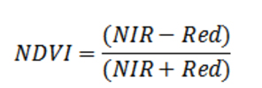
NDVI: Simply put, Normalized Difference Vegetation Index is a calculation of vegetation or crop health using a visible band of light (usually red) that our eyes can see, as well as an NIR band of light that our eyes cannot see. NDVI values range from -1 to 1, which is then created into a color scale that our eyes can interpret. Values between -1 and 0 correspond to non-plant surfaces that have a reflectance in the red that is greater than the reflectance in the NIR. These could be surfaces such as equipment, water, or soil.

The NDVI mathematical formula compares NIR and red light to accurately show crop health. Output values range from -1 to 1.
Plant values normally range from 0.1 to nearly 1, with the higher the NDVI value, the greater the plant density and health. NDVI has a variety of uses, with its most valuable one being able to accurately measure crop health, despite changing weather conditions. This means you can compare different NDVI map data over time, even with changes in sunshine and cloud cover from day-to-day or week-to-week. This capability is important for agronomists who are working with farmers throughout the season,and for service providers who are selling drone mapping for hire year-round.
An Alternative To False-NDVI
If you don’t have access to an NIR sensor and still want to measure plant health using an RGB sensor, there is an alternative to false-NDVI you may want to look into. The Visible Atmospherically Resistant Index (VARI) algorithm, designed and tested to work with RGB sensors. This is a more useful and accurate way to measure plant health using RGB imagery. The VARI algorithm uses color correction to minimize reflectance, scattering, and other atmospheric effects to better estimate the fraction of healthy vegetation in an area. It helps show how green a plant is in comparison to others so you can approximate the relative plant health and vigor. We do not consider this index a substitute for an NIR sensor, but it is a meaningful algorithm to use when working with non-NDVI imagery as it helps detect areas of crop stress in a field at greater accuracy than false-NDVI.

The VARI mathematical formula compares the values of green, red, and blue light to estimate crop health.
In short, although VARI is not a replacement for NDVI, the VARI algorithm applied to an RGB sensor provides useful information related to variance at a single point in time. It can also be a valuable tool to help farmers identify stress and generate variable rate prescriptions.
So What Do We Recommend?
Botlink strongly recommends NIR sensors. They give you the best possible data you can get and provides you with the most accurate indication of plant health every single time. An NIR sensor is the only way to create NDVI maps that detect problems much sooner than the visible eye can see. The information these maps provide help you make more accurate comparisons throughout the year, or from season-to-season, so you can visualize progress and adjust accordingly.
How To Upgrade Your Drone For NDVI
RGB sensors are easy to find on consumer drones, while NIR sensors are only found on specific drones or have to be added on. We have affordable options for anyone looking to purchase a drone with an NIR sensor. Check out our drone bundles to get a drone equipped with an NIR sensor and one year of Botlink Professional image processing services included. Some other options include AgEagle drones that come equipped with Sentera NIR sensors.
If you already have a drone and would like to use an NIR sensor, Sentera has an upgradefor common DJI™ drones which will work with the Botlink Capture app as well!
In Conclusion
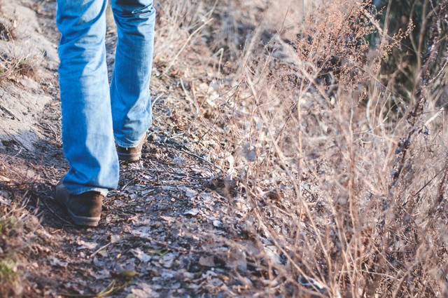
Drones make field scouting faster and more effective, period. But, drones cannot replace humans altogether since they can’t tell us what causes the variability. That’s why no matter what method or calculation you use, it’s always important to ground truth and take samples before making any final decisions. Once the variability is found, put on some boots, go right to the source of the problem, and determine the best course of action.

Photo via unsplash.com
The content & opinions in this article are the author’s and do not necessarily represent the views of AgriTechTomorrow
Comments (1)
Featured Product

